The second Spread Eagle Walking Group walk - Darrington to Kirk Smeaton via Wentbridge
Date: Sunday 21st January 2013
Walkers: Amanda, Anne, Avril, Dave, Fiona, Joan, Ian, Jonathan, Mick, Nick, Peter, Peterjohn, Sue,
Start and Finish: Darrington
Distance: Approximately 8 miles Difficulty: Easy, flat route but snowy and slippy
Weather: Cold but bright
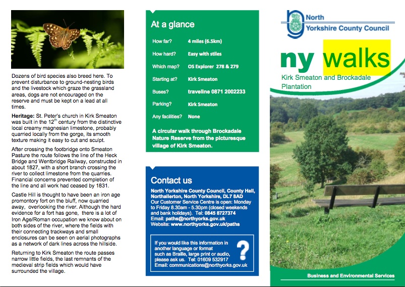
Interest points: Wentbridge, Brockadale nature reserve, Kirk Smeaton, Shoulder of Mutton
Libation and fodder: Cath and Mick’s house
Walkers: Amanda, Anne, Avril, Dave, Fiona, Joan, Ian, Jonathan, Mick, Nick, Peter, Peterjohn, Sue,
Start and Finish: Darrington
Distance: Approximately 8 miles Difficulty: Easy, flat route but snowy and slippy
Weather: Cold but bright
Interest points: Wentbridge, Brockadale nature reserve, Kirk Smeaton, Shoulder of Mutton
Libation and fodder: Cath and Mick’s house
The second SWAG walk was in snowy weather so we decided to walk from the village to Kirk Smeaton and back. It was a circular walk although we retraced our steps along Westfield Lane – it was extremely icy going from the village, but it had thawed by the time we returned in the afternoon. Unfortunately we had our first casualty of SWAG as Anne badly twisted her ankle soon after we left Wentbridge crossing the field and woods to Smeaton. Fortunately as, whilst most of us were oblivious to Anne’s predicament, Peter and Mick supported Anne back to the road in Wentbridge and Cath came to the rescue in her car.
1
1
Mick managed to join us in The Shoulder of Mutton for refreshments proving that he walked quicker than anyone else!!! On returning from the walk, which was enjoyable and invigorating, Billy and Cath greeted us and there was stew, shepherd’s pie and two puddings, along with alcoholic beverages, to sustain us for the rest of the day. Many thanks to Cath for providing this.
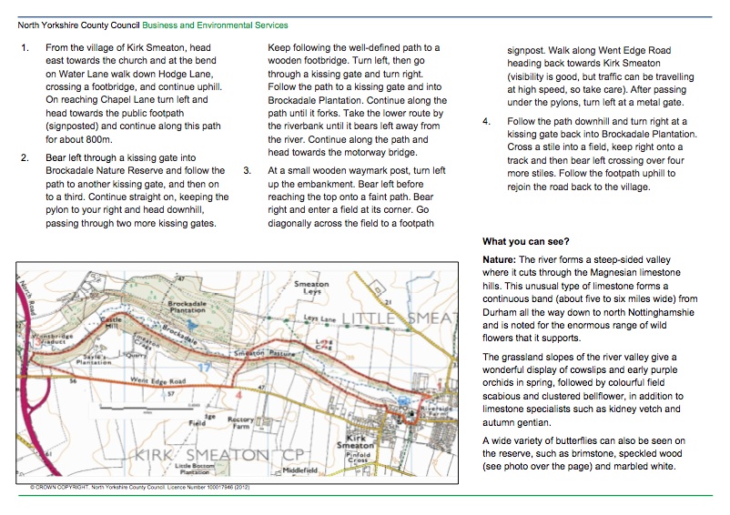
The walk from Wentbridge to Kirk Smeaton can be found at the following websites:
2
The walk from Wentbridge to Kirk Smeaton can be found at the following websites:
2
http://www.northyorks.gov.uk/CHttpHandler.ashx?id=7145&p=0
http://www.wentbridgehouse.co.uk/blog/introducing-the-wentbridge-walk/
http://www.brockadale.org.uk/Home.html
http://www.wildlifetrusts.org/reserves/brockadale-nature-reserve
http://www.wentbridgehouse.co.uk/blog/introducing-the-wentbridge-walk/
http://www.brockadale.org.uk/Home.html
http://www.wildlifetrusts.org/reserves/brockadale-nature-reserve
| kirk_smeaton_and_brockadale_plantation1.pdf |
The 3rd SWAG Walk, February 17th, with: Avril, Jonathon, Cath, Mick, Billy, Sue, Ian, Joan, Peterjon, Tim, Joan, Phil
Although we started and finished the walk from the Chequers, the walk below is an alternative, if you want to spend time at the Ings.
Fairburn Ings and Ledsham
A visit to West Yorkshire's very own 'Lake District', now a bird reserve of national importance.
Distance 5 miles (8km)
Minimum time 2hrs 30min
Ascent/gradient 131ft (40m)
Level of difficulty Easy
Paths Good paths and tracks (some newly-created from spoil heaps), 7 stiles
Landscape Lakes, riverside and reclaimed colliery spoil heaps
Dog friendliness: Keep on lead around main lake, due to wildfowl
Parking Free parking in Cut Road, Fairburn. From A1, drive into village, turn left 100yds (91m) past Three Horseshoes pub,
Public toilets Fairburn Ings visitor centre
1 Walk down Cut Road as it narrows to a track. Soon you have the main lake to your right, and a smaller stretch of water to your left. When the track forks, keep right (unless you want to visit the first of the bird hides, in which case detour to the left). The path finishes at the end of the lake, on approaching the River Aire.
2 Go right here, to join a path along the top of a ridge (actually an old spoil heap), with the river to your left and the lake right. Look out for a couple of other bird hides, before you lose sight of the lake. The path crosses a broader expanse of spoil heap, through scrubland, following the river in a broad arc to the right, before descending to a stile above another small mere. Bear right on a broad track and drop down into the car park of the Fairburn Ings visitor centre.
3 Meet a road. Go right for 100yds (91m), then go left (signed 'Ledston and Kippax') for just 100yds (91m), and pick up a path on your right that hugs the right-hand fringe of a wood. Beyond the wood, take a path between fields; it broadens to a track as you approach the village of Ledsham. At a new estate of houses, turn right, along Manor Garth.
4 You arrive in the village by the ancient church. Walk right, along the road (or, for refreshments, go left to the Chequers Inn). Beyond the village, where the road bears left, take a gate on the right, giving access to a good track uphill. Where the main track goes right, into fields, continue along a track ahead, into woodland. Leave the wood by a stile, crossing pasture on a grassy track. Two stiles take you across a narrow spur of woodland.
5 Head slightly left, uphill, across the next field, to follow a fence and hedgerow. Continue - soon on a better track - across a stile. Beyond the next stile the track bears left, towards farm buildings: but you keep straight on, with a fence on your right, along the field path. Through a metal gate, join an access track downhill. Go left, when you meet the road, and back into the village of Fairburn.
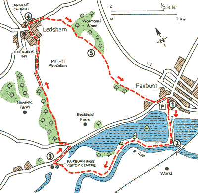
A useful map of the Fairburn Ings circular walk
The fourth SWAG walk
Heath Common and the Southern Washlands
Date: Sunday 17th March 2013
Walkers: Avril, Jonathan, Mick, Cath, Joan, Phil, Fiona, Nick, Tim, Billy
Start and Finish: Heath Common Car Park
Distance: Approximately 6 and a half miles
Difficulty: Easy, flat route
Weather: Cold but bright
Interest points: Heath Common; Goose Common; Kirkthorpe Stocks; Half Moon Lake; Reclaimed colliery land with streams, ponds, grasslands; River Calder; Aire and Calder Navigation; Blue Bridge; Kirkthorpe Weir view point
Libation and fodder: The Kings Arms
This walk connected the following two walks on the Wakefield Council website (http://www.wakefield.gov.uk/CultureAndLeisure/outdoors/Walking/LongerWalks/default.htm).
Heath Common through Goose Common and Kirkthorpe
A beautiful old Common near the Georgian village of Heath. The village is designated a conservation area of outstanding architectural and historic interest. The Common was saved from enclosure in the 1840s by the famous naturalist Charles Waterton, who wrote, "It is beautiful in nature's wildest charms". Today it is leased to Wakefield Council by the Heath Estate. (NB Only horse owners who hold licences, issued by the Council, will be granted approval for grazing on Council managed land. This is due to unacceptable increase in horse numbers overgrazing our Commons.)’ (http://www.wakefield.gov.uk/CultureAndLeisure/ParksAndOpenSpaces/Commons/default.htm). ‘Wakefield was mainly settled by Danes, and was the centre of the wapentake of Agbrigg. The local court met around the Heath Common area. It has been claimed that Wakefield was the Scandinavian capital of the whole of the West Riding.’ (http://freepages.genealogy.rootsweb.ancestry.com/~petyt/wakefieldhistory.htm).
The Southern Washlands
‘This site is in the Lower Calder Valley and forms part of the flood basin for the River Calder. Once worked for sand and gravel it was restored in 1987 as a reserve and is one of several wetland sites in the Lower Calder Valley. A variety of habitats – open water, swamp, marshy grassland, willow and hawthorn scrub – are home to a variety of wildflowers, birds and amphibians. The air is filled with butterflies and dragonflies in the summer. There are a variety of birds including kingfisher, green woodpecker and water birds. Other wetland sites within walking distance include Stanley Ferry Flash to the north (1 km), and Stanley Marsh Nature Reserve (2.4 km)’ (http://www.lnr.naturalengland.org.uk/Special/lnr/lnr_details.asp?C=45&N=&ID=415
Written by Avril
